
Save Mystic Lake
Prepared by Save Mystic Lake Working Group August 2025
Mystic Lake—one of Southern California’s most biologically significant inland wetlands—is protected as public conservation land, yet its future remains precarious. Pressures from urban expansion, infrastructure development, groundwater depletion, and hydrological disruption threaten to destabilize the ecological, geological, and cultural systems that sustain the lake.
This white paper outlines why traditional development models that ignore fault lines, water flows, fire regimes, and cultural histories pose unacceptable risks. Mystic Lake and the surrounding area require a holistic, science-driven, and community-centered approach to land-use decision-making.
Mystic Lake’s unique position as a subsidence basin in a fire-prone area within an active fault system means that disturbance to the landscape can magnify risks to nearby communities. Misaligned development may worsen the impacts of floods, subsidence, habitat loss, and contamination while imposing extreme financial liabilities. Conversely, a regenerative and systems-oriented planning framework with transparent, community-accessible geospatial analysis can safeguard ecological health while preventing costly disasters.
A Biodiversity Reservoir of National Significance
Mystic Lake is a subsidence basin that forms a wide lakebed within the San Jacinto River floodplain (Morton, Douglas M. 1977). Historically, the lake would often hold water for many years, drying up only during the periodic regional droughts. This pattern sustained riparian, marshes, and wetlands. The dry periods created a unique and vibrant ecosystem of grassland meadows and a diversity of flowering plants.
For more than a century, Mystic Lake has been a magnet for ornithologists and bird enthusiasts from around the world. Within the lake basin alone, 273 species have been reliably recorded; including the adjacent uplands raises that number to 317 species—an unparalleled concentration in Riverside County. These include:
- Migratory waterfowl dependent on seasonal inundation
- State- and federally listed species such as the tricolored blackbird
- Wintering raptors including ferruginous hawks
- Shorebirds and rare grassland specialists such as the mountain plover
In an era when similar inland marshes are disappearing throughout the West, Mystic Lake provides irreplaceable stopover and breeding habitat across international flyways. Disrupting the water that flows into Mystic Lake will not only disrupt birds and the broader ecosystem but the economic benefits of related tourism.
Interacting Systems: Hydrology, Geology, Ecology, and Fire
A Fault-Controlled Lake Basin
Mystic Lake sits on top of an active system shaped by the San Jacinto and Casa Loma faults. These faults continually reform the landscape, causing:
- Cracking and heaving of the lakebed
- Ongoing subsidence that expands the basin
- Localized variations in groundwater flow
Ignoring these geological forces when siting buildings, utilities, or roads increases long-term risk and guarantees massive maintenance and liability costs.
Hydrological Disruption and Subsidence
Over the last century, channelization of the San Jacinto River, levee construction, and groundwater extraction have dramatically altered natural flows. Key consequences include:
- Interruption of historical surface water recharge
- Sediment-clogged inlets that prevent lake replenishment
- Accelerated basin subsidence due to groundwater declines
- Heightened flood risk during atmospheric rivers and El Niño cycles
The river has repeatedly attempted to return to its natural course—1942, 1969, 2004, 2011, 2019, 2023—overtopping or breaching levees and flowing directly into Mystic Lake.
Fire, Drought, and the Expanding Urban Edge
As development spreads across the valley, fire hazards to human communities and the human built environment will increase.
Over 90% of the project area for one new development (Rancho Belago) is in a high or very high fire hazard severity zone. This means that the homes there will be unable to retain conventional home insurance and that the adjacent hills will continue their pattern of historical burning, putting communities at risk.
A wildfire or flood event in an improperly planned development zone will carry cascading impacts across the valley’s roads, aqueducts, and utilities.
Rare and Endangered Botanical Communities
The hydrological variability of the San Jacinto Valley supports a suite of rare and at-risk plant communities: alkaline playas, alkali grasslands, and vernal pools. These habitats host:
- San Jacinto Valley crownscale (federally endangered)
- Thread-leaved brodiaea (federally threatened; state endangered)
- Davidson’s salt scale, Parish’s brittle scale, Wright’s trichocoronis, and other endemics
Because many of these species occur only in the valley, any alteration to hydrology or soil alkalinity threatens extinction-level outcomes.
An Indigenous Cultural Landscape
Mystic Lake and the surrounding valley lie within the ancestral territory of the Soboba Band of Luiseño Indians, whose members descend from both Cahuilla and Luiseño lineages. For generations, the people of Soboba managed the valley’s waters through surface-water irrigation, springs, and riparian systems. Historic accounts—from Juan Bautista de Anza to Father Francisco Garcés—document a vibrant river valley full of abundant wildlife, fertile land, and marshlands.
Stewardship today must honor not only ecological function but also the deep cultural continuities that bind the Soboba community to these landscapes.
Conclusion
The spectacular Mystic Lake remains the heart of the San Jacinto Wildlife Area (Lowther 2025) thanks to a coalition of the Friends of the Northern San Jacinto Valley, San Gorgonio Chapter of the Sierra Club, San Bernardino Valley Audubon Society, along with concerned individuals and the support by CDFW (Hague 2025).
Ecology, biology, hydrology, and geology are all distinct parts of a unified life force expressing itself at Mystic Lake. Mystic Lake is the result of a living system that extends far beyond its shores. Not just the lake but the systems that create deserve protection.
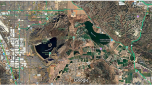 Figure 1. Satellite Imagery of San Jacinto Wildlife Area, Mystic Lake, San Jacinto River, and remaining agricultural lands (Google Earth 2025).
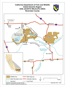 Figure 2. Map of San Jacinto Wildlife Area Units (CDFW 2025).
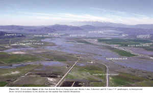 Figure 3. Example flooding event of the San Jacinto Valley, Mystic Lake, and San Jacinto Wildlife Area (Morton and Miller 2006)
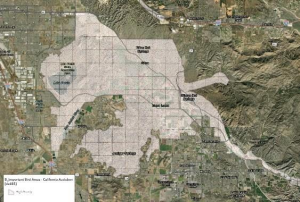 Figure 4. Areas in San Jacinto Valley known to support migratory bird nesting and over-wintering (Metcalf 2024, Audubon 2025).
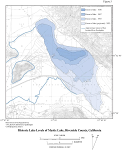 Figure 5. Mystic Lake Historic and Projected Extent of Subsidence from 1938 to 2023 (Morton 1977, Morton and Douglas 2006).
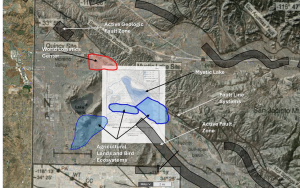 Figure 6. Ecologically, Biologically Active Mystic Lake Ecosystem (Mapsol 2025).
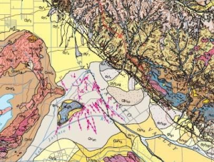 Figure 7. North San Jacinto Valley and San Jacinto Wildlife Area region as mapped in “Geologic map of the San Bernardino and Santa Ana 30′ x 60′ quadrangles, California,” by Douglas M. Morton and Fred K. Miller Digital preparation by Pamela M. Cossette, and Kelly R. Bovard Geology and Description of Map Units, version 1.0 Open-File Report 2006-1217, Online version 1.0 http://pubs.usgs.gov/of/2006/1217, 2006.
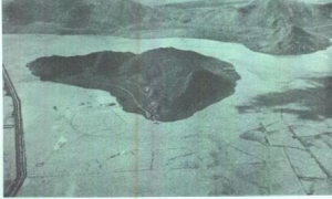 Figure 8. “Cover Photo. Aerial view of San Jacinto River, looking downstream. during the flood of February 1969. Note the low flow channel at left” in Flood Plain Information San Jacinto River (San Jacinto to Railroad Canyon Riverside Couty California), prepared for Riverside County by Corps of Engineers, U.S. Army Los Angeles District, CA, May 1970.
Works Cited
Army Corps of Engineers (ACOE) 1970. Flood Plain Information San Jacinto River (San Jacinto to Railroad Canyon Riverside Couty California), prepared for Riverside County by Corps of Engineers, U.S. Army Los Angeles District, CA, May.
Audubon Society 2025. “What We Do – Conservation.” https://www.sbvas.net/what-we-do. Accessed 14 August 2025.
Beaumont Gazette 1939. “Dream Comes True in Construction of Giant Aqueduct, San Jacinto Tunnel Was Holed Through During Past Year, flThirteen-Mile Aqueduct Bore Under Mt. San Jacinto Near Completion” in Daily Gazette (Beaumont), Volume XXXII, Number 24, 15 June 1939. Accessed at https://cdnc.ucr.edu/?a=d&d=BMTG19390615.2.21
Bolton 1930, Herbert E., editor. Anza’s California Expeditions. Internet Archive ed., New York, Russell and Russell, 1966. 1 to 5 vols.
CDFW 2025. “History of the San Jacinto Wildlife Area.” California Department of Fish and Wildlife, CDFW, 2025, https://wildlife.ca.gov/Lands/Places-to-Visit/San-Jacinto-WA#610874027-learning-and-getting-involved. Accessed 13 August 2025.
California Department of Water Resources (CA DWR) 2022. Infrastructure Resilience Report.
Hague, George 2025. Correspondence with Co-founder, Friends of the North San Jacinto Valley.
Huntington Library 2025. Coming to California Juan Bautista de Anza Establishes a Land Route. Grade 4 California History Paper, Pens & Prose. Pasadena, CA, USA, https://www.huntington.org/sites/default/files/pdfs/lhpppcoming2calif.pdf. Accessed 13
Aug. 2025.
Lockheed Martin 2025. “Remediation Beaumont, California.” Lockheed Martin, https://www.lockheedmartin.com/en-us/who-we-are/eesh/remediation/beaumont.html. Accessed 14 August 2025.
Los Angeles Times 2025. “A rare glimpse inside the mountain tunnel that carries water to Southern California.” Los Angeles Times, 27 April 2025, https://www.latimes.com/environment/story/2025-04-27/water-tunnel-under-mount-san-jacinto. Article by Ian James. Accessed 14 August 2025.
Los Angeles Times 1990. “$5-Million Lawsuit Filed as Cracks Plague 2nd Palmdale Subdivision” written by John Chandler, Dec 15, 1990.
Lowther, Greg 2025. “Mystic Lake acquisition and transfer to CDFW”, First National Investment Properties. Correspondence on August 15, 2025.
Mapsol 2025. Georeferencing for conservation: Enhancing and environmental awareness. https://mapsolgeo.com. Dr. Kiran Manchikanti, CEO & Founder, kiran@mapsolgeo.com.
Metcalf, Anthony. PhD. 2024. Avian Diversity in the Northern San Jacinto Valley. PowerPoint presentation. Nov. 2024 at NSJV Regional Symposium. CSU-SB.
MWD 2025. Our Story. Metropolitan Water District of Southern California. https://www.mwdh2o.com/our-story/people-gallery/. Website accessed Aug 14, 2025.
Morton, Douglas and Fred Miller 2006. “Figure 5. Historic Lake Levels of Mystic Lake, Riverside County, California” and Photo 242. Flood plain (Qyva) of the San Jacinto River in foreground and Mystic Lake, Lakeview and El Casco 7.5′ quadrangles, in background. Snow covered mountains on the skyline are the eastern San Gabriel Mountains.” in Geologic Map of the San Bernardino and Santa Ana 30’ x 60’ quadrangles, California. Open-File Report 2006-1217. http://pubs.usgs.gov/of/2006/1217.
Morton, Douglas M. 1977. “Surface Deformation in Part of the San Jacinto Valley, Southern California (Figure 5-A to F. photos)” in Journal Research U.S. Geo Survey, vol. 5, no. 2, 1977, pp. 117-124.
National Park Service 2022. “The Mexican American War” https://www.nps.gov/places/the-mexican-american-war.htm, accessed 14 August 2025.
Riverside County Flood Control & Water Conservation District (RCFCWCD) 2023.
Annual Report.
Riverside County Parks 2024. Vegetation Communities, Rare Plants & Sensitive Wildlife Species of the San Jacinto Valley. PowerPoint presentation. Riverside, CA, Nov. 2024, p. 26.
San Bernardino Valley Audubon Society. “What We Do – Conservation.” San Bernardino Valley Audubon Society, 2025, https://www.sbvas.net/what-we-do. Accessed 14 August 2025
San Jacinto Basin Resource Conservation District. Birds of the San Jacinto Valley Important Bird Area. pamphlet. San Jacinto, https://www.sjbrcd.org/files/32839473b/Birds+of+the+San+Jacinto+Valley.pdf Accessed 13 Aug 2025.
Sewell, Scott 2025. Senior Supervisor and Wildlife Area Manager. email correspondence on Aug. 11, 2025. San Jacinto Wildlife Area, Nuevo, CA, USA.
Soboba Band of Luiseno Indians, 2025 “Soboba – A Proud Nation” in About Us: History. https://www.soboba-nsn.gov/about-us#history.
U.S. Geological Survey 1901. Elsinore, CA. 1:125,000 quadrangle.
USGS 1942. Perris, CA. 1:65,500 quadrangle.
WPA 2025. Construction of the Colorado River Aqueduct. Water and Power Museum. https://waterandpower.org/museum/Colorado%20River%20Aqueduct.htmlWPA . Website accessed on Aug 14, 2025.
Wildon, Bert 2014, “The San Jacinto River Valley that Juan Bautista de Anza saw.” Earth’s Internet & Natural Networking, blog, 3 May 2014, https://creating-a-new-earth.blogspot.com/2014/05/the-san-jacinto-river-valley-that-juan.html. Accessed 13 August 2025.
World Be Well 2025. “Our Focus Areas”, https://worldbewell.org/
Prepared by Maria Lum, Tony Metcalf, and Kiran Manchikanti.
 Lords of Sunnymead Foundation
©2026 Lords of Sunnymead Foundation
All Rights Reserved